


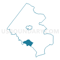
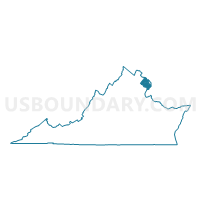
Fountainhead Voting District, Fairfax County, Virginia
About
Outline

Summary
| Unique Area Identifier | 681564 |
| Name | Fountainhead Voting District |
| County | Fairfax County |
| State | Virginia |
| Area (square miles) | 12.18 |
| Land Area (square miles) | 11.53 |
| Water Area (square miles) | 0.65 |
| % of Land Area | 94.65 |
| % of Water Area | 5.35 |
| Latitude of the Internal Point | 38.73206610 |
| Longtitude of the Internal Point | -77.30792820 |
Maps

Graphs
Select a template below for downloading or customizing gragh for Fountainhead Voting District, Fairfax County, Virginia


Neighbors
Neighoring Voting District (by Name) Neighboring Voting District on the Map
- Clifton Voting District, Fairfax County, VA
- Lake Ridge Voting District, Prince William County, VA
- McCoart Voting District, Prince William County, VA
- Mohican Voting District, Prince William County, VA
- Rockledge Voting District, Prince William County, VA
- Silverbrook Voting District, Fairfax County, VA
- South County Voting District, Fairfax County, VA
- Woodyard Voting District, Fairfax County, VA
Top 10 Neighboring County Subdivision (by Population) Neighboring County Subdivision on the Map
- Mount Vernon district, Fairfax County, VA (106,296)
- Springfield district, Fairfax County, VA (101,682)
- Coles district, Prince William County, VA (51,770)
- Occoquan district, Prince William County, VA (40,241)
Top 10 Neighboring Place (by Population) Neighboring Place on the Map
Top 10 Neighboring Unified School District (by Population) Neighboring Unified School District on the Map
Top 10 Neighboring State Legislative District Lower Chamber (by Population) Neighboring State Legislative District Lower Chamber on the Map
- State House District 42, VA (81,840)
- State House District 40, VA (80,835)
- State House District 51, VA (77,333)
- State House District 41, VA (70,634)
Top 10 Neighboring State Legislative District Upper Chamber (by Population) Neighboring State Legislative District Upper Chamber on the Map
Top 10 Neighboring 111th Congressional District (by Population) Neighboring 111th Congressional District on the Map
Top 10 Neighboring Census Tract (by Population) Neighboring Census Tract on the Map
- Census Tract 4922.02, Fairfax County, VA (6,844)
- Census Tract 4921, Fairfax County, VA (6,313)
- Census Tract 9012.23, Prince William County, VA (6,265)
- Census Tract 9012.19, Prince William County, VA (5,519)
- Census Tract 9012.21, Prince William County, VA (5,080)
- Census Tract 4922.03, Fairfax County, VA (4,065)
- Census Tract 4925, Fairfax County, VA (4,064)
- Census Tract 9012.35, Prince William County, VA (3,052)
- Census Tract 4922.01, Fairfax County, VA (2,761)
- Census Tract 9012.22, Prince William County, VA (2,604)